Projects | CIS Projects | Digital Lodgement
Digital Data Formats Investigation
Formats
Based on the findings tabulated, formats for the lodgement of digital data for Phase 1 (the numerics) have been investigated. The following is proposed :
HEADER DATA
Surveyor Name
Submission date (in the format dd.mm.yyyy)
Document type (D for diagram, and G for general plan)
Province | Admin. District or Registration Division | Allotment Area or Township Name
Coordinate System (e.g. WG23)
Y-Constant | X-Constant
PARCEL DATA
Parcel number | Portion number | Area (in square metres)
Point name | Distance | Direction | Y-coordinate | X-coordinate
Point name | Distance | Direction | Y-coordinate | X-coordinate
Point name | Distance | Direction | Y-coordinate | X-coordinate
Point name | Distance | Direction | Y-coordinate | X-coordinate
MAIN FIGURE DATA
Point name | Distance | Direction | Y-coordinate | X-coordinate
Point name | Distance | Direction | Y-coordinate | X-coordinate
Point name | Distance | Direction | Y-coordinate | X-coordinate
Point name | Distance | Direction | Y-coordinate | X-coordinate
Point name | Distance | Direction | Y-coordinate | X-coordinate
Point name | Distance | Direction | Y-coordinate | X-coordinate
Point name | Distance | Direction | Y-coordinate | X-coordinate
Point name | Distance | Direction | Y-coordinate | X-coordinate
Point name | Distance | Direction | Y-coordinate | X-coordinate
EXCLUDED FIGURE DATA
Point name | Distance | Direction | Y-coordinate | X-coordinate
Point name | Distance | Direction | Y-coordinate | X-coordinate
Point name | Distance | Direction | Y-coordinate | X-coordinate
Point name | Distance | Direction | Y-coordinate | X-coordinate
Point name | Distance | Direction | Y-coordinate | X-coordinate
Point name | Distance | Direction | Y-coordinate | X-coordinate
Point name | Distance | Direction | Y-coordinate | X-coordinate
Point name | Distance | Direction | Y-coordinate | X-coordinate
Point name | Distance | Direction | Y-coordinate | X-coordinate
BLOCK DATA
Point name | Y-coordinate | X-coordinate
Point name | Y-coordinate | X-coordinate
Point name | Y-coordinate | X-coordinate
Point name | Y-coordinate | X-coordinate
Point name | Y-coordinate | X-coordinate
Point name | Y-coordinate | X-coordinate
Point name | Y-coordinate | X-coordinate
Point name | Y-coordinate | X-coordinate
Point name | Y-coordinate | X-coordinate
Point name | Y-coordinate | X-coordinate
Point name | Y-coordinate | X-coordinate
Point name | Y-coordinate | X-coordinate
Point name | Y-coordinate | X-coordinate
Point name | Y-coordinate | X-coordinate
Point name | Y-coordinate | X-coordinate
CONNECTIONS DATA
Point name from | Distance | Direction | Point name to
Point name from | Distance | Direction | Point name to
Point name from | Distance | Direction | Point name to
Point name from | Distance | Direction | Point name to
SPLAYS DATA
Apex Point name
Setback distance | Setback distance
Direction to Apex Point | Direction from Apex Point
Base from Point name | Base to Point name | Base distance | Base direction
Apex Point name
Setback distance | Setback distance
Direction to Apex Point | Direction from Apex Point
Base from Point name | Base to Point name | Base distance | Base direction
General notes on the proposed format
- The proposed format is a straight forward (MS DOS-based) ASCII text file.
- Headings serve to differentiate between different data sets and are depicted by two sets/strings of hyphen characters (ASCII character 45).
- The pipe character (ASCII character 179) is to be used as a delimiter to separate all entities. This should eliminate confusion created by the use of a comma (and the other more common delimiters) which could appear as part of the actual data.
- A carriage return character (ASCII control character 13) is to denote the end of each line.
- Two carriage return characters in succession (i.e. a blank line) separates one feature (i.e. parcel, block, splay or connection feature) from another.
- The full-stop character (ASCII character 46) is used in the numerics to indicate decimals. It is also used to separate date entries and direction entries (i.e. 01.08.2000 and 180.30.20 respectively), dates being in the format dd.mm.yyyy and directions in the format ddd.mm.ss.
- All point names are graphic names as reflected on the conventional diagrams and general plans, not the names in the surveyor's (e.record) coordinate list. Also, in all cases "Point name" refers to "From Point name" unless otherwise specified.
- If no Apex Point exists with a splay, then the setback distance will be 0.
- Also with splays, in the case of unequal setbacks two setback distances need to be supplied.
- Explanation of the components of a splay:
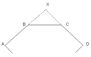
X - Apex Point
AB - Direction to Apex Point
CD - Direction from Apex Point
BC - Base
BX, CX - Setback distances
The Formats task team submitted the proposed formats to a number of survey software developers. Feedback from these vendors is very encouraging.
<< Previous | Next >>