Home

Chief Surveyor General

It is our mission to provide Quality Services that ensure the Integrity of Surveyed Real Rights and to supply, maintain and provide access to Spatially Related Information for the People of our Country.

Structure Functions Data Projects Client Profile Contact Us
Search Papers Press Office Legal Info Links Fees


Projects | CIS Projects | Spatial Data


Project Miracle

Project Definition

What is to be achieved?

The capture of the South African Urban Cadastral Database in digital format into a continuous geographic database for every province, and capture the enumerated census areas for those urban areas that have not yet been completed in Project Miracle.

How?

  • Negotiate with local authorities and other owners of digital data for the use of their data within the provided mandate
  • Get external contractors to convert this data into UCD format after getting quotes for this work
  • Check this digital data for accuracy, completeness and key (unique identifier) correctness
  • Featurize this data
  • Import the featurized data into the master database
  • Put out tenders for the capture of data from general plans for areas where no digital data exists
  • Scan and vectorise data for which there is no digital data available, and for which there are no general plans available
  • Capture the enumerated census areas from maps supplied by Statistics South Africa.

By When?

From April 1997 to end January 1998.

By Whom?

  • Surveyor General personnel in office hours
  • Surveyor General personnel working overtime in the week and on weekends
  • Contractors working shifts in the week and on weekends
  • External contractors converting data into the UCD drawing format
  • External contractors capturing general plans
  • Surveyor General personnel scanning and vectorising other diagrams

Top

Project Team

Top

Project Volumes

Top

Project Costs

Top

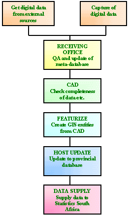
Process Flow in each Surveyor General Office

Top

Back to Projects